![]()
![]()
![]()

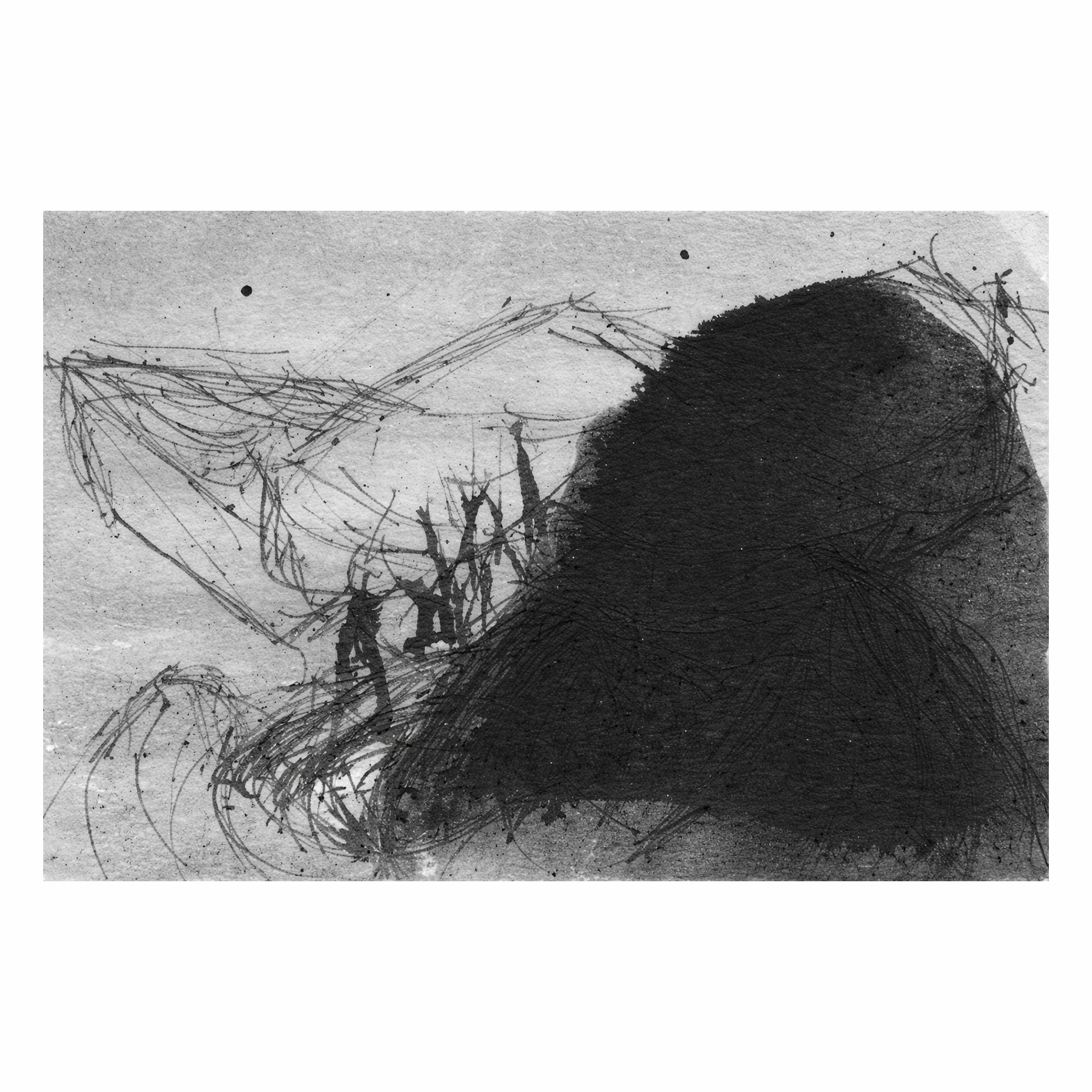
Marcello Mercado, Eismeer (Sea of Ice), 2012.
Artist’s book / book-object, detail (individual identifier with ink drawing).
Ink on paper, metal pin.
9 × 26 cm (overall), 26 parts.![]()

Marcello Mercado, Eismeer (Sea of Ice), 2012.
Artist’s book / book-object, detail (individual identifier with ink drawing).
Ink on paper, metal pin.
9 × 26 cm (overall), 26 parts.
![]()

Marcello Mercado, Eismeer (Sea of Ice), 2012.
Artist’s book / book-object, detail (individual identifier with ink drawing).
Ink on paper, metal pin.
9 × 26 cm (overall), 26 parts.
![]()
Marcello Mercado, Eismeer (Sea of Ice), 2012.
Artist’s book / book-object, detail (individual identifier with ink drawing).
Ink on paper, metal pin.
9 × 26 cm (overall), 26 parts.
![]()
Marcello Mercado, Eismeer (Sea of Ice), 2012.
Artist’s book / book-object, detail (individual identifier with ink drawing).
Ink on paper, metal pin.
9 × 26 cm (overall), 26 parts.
![]()
Marcello Mercado, Eismeer (Sea of Ice), 2012.
Artist’s book / book-object, detail (individual identifier with ink drawing).
Ink on paper, metal pin.
9 × 26 cm (overall), 26 parts.
![]()
![]()
![]()
![]()
Eismeer, 2012
Künstlerbuch / Buchobjekt
9 × 26 cm, 26 Teile
![]()
Eismeer (Sea of Ice) präsentiert sich als ein Buch, das die Bindung aufgegeben hat, um zu einer Konstellation tragbarer Fragmente zu werden. Die Arbeit besteht aus 26 Identifikatoren—individuellen Ausweisen, die dafür konzipiert sind, am Körper getragen zu werden—von denen jeder eine kleine Tuschezeichnung enthält. Diese Zeichnungen sind weder freie Bilder noch imaginierte Landschaften: Jede bezieht sich auf eine spezifische Koordinate, die mithilfe von Google Maps im antarktischen Territorium lokalisiert wurde.
![]()
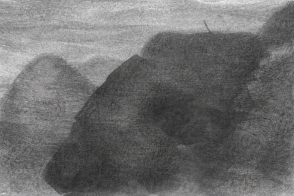
Die zentrale Geste der Arbeit ist nicht die Darstellung des Eises, sondern seine Auflösung. Das Eismeer erscheint nicht als visuelle Totalität, sondern als Summe getrennter, autonomer und verschiebbarer Teile. Der Bezug auf Caspar David Friedrich fungiert hier nicht als ikonografisches Zitat, sondern als strukturelle Resonanz: So wie sich in Das Eismeer die Landschaft in gewaltsam übereinandergeschobene Platten zerteilt, wird das antarktische Territorium in dieser Arbeit in minimale Einheiten zerlegt—nicht mehr malerisch, sondern informationell und körperlich.
![]()
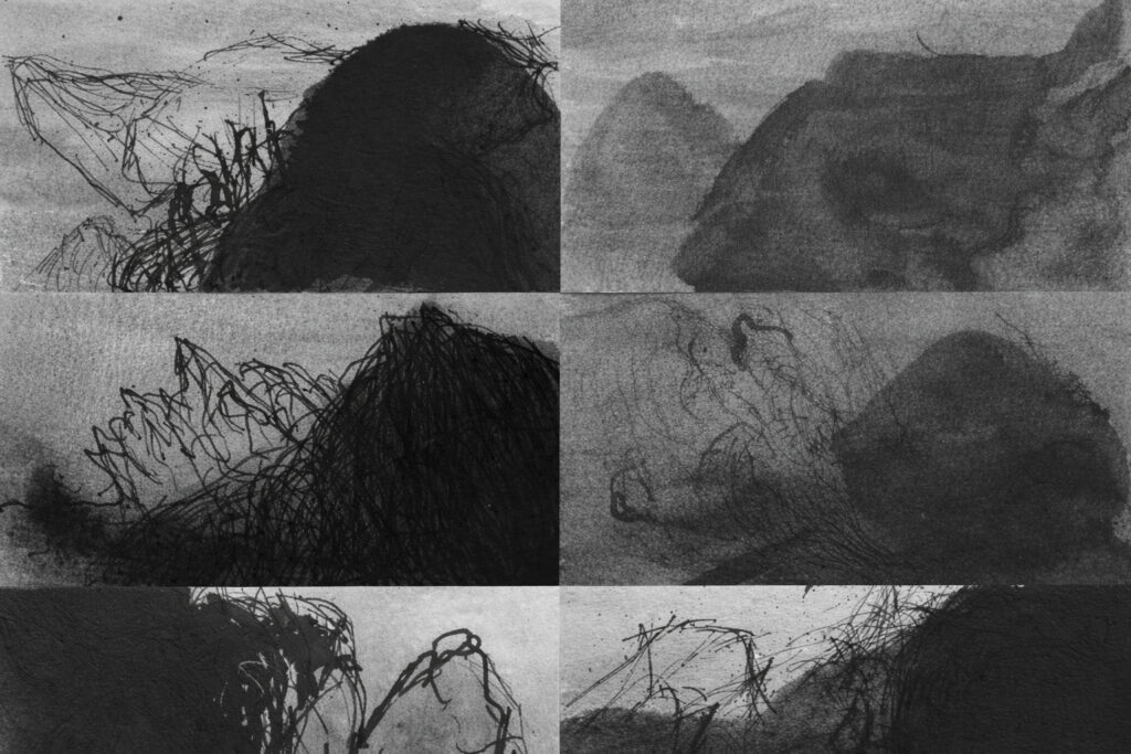
Jeder Identifikator fungiert als einem Körper zuweisbares Landschaftsfragment. Die Arbeit wird erst dann vollständig aktiviert, wenn sechsundzwanzig Personen diese Elemente gleichzeitig tragen und das Eismeer durch eine menschliche Verteilung neu zusammensetzen. Das Territorium wird nicht aus der Distanz betrachtet, sondern getragen, bewegt und temporär verkörpert. Kartografie hört auf, eine globale Abstraktion zu sein, und wird zu einer kollektiven Choreografie.
![]()
Der Einsatz von Google Maps führt eine entscheidende technologische Ebene ein: den satellitengestützten, kontinuierlichen Fernzugang zu einem für die meisten unzugänglichen Territorium. Doch anstatt die Logik des digitalen Bildes zu reproduzieren, übersetzt Mercado diese Koordinaten in eine manuelle Zeichnung und stellt damit eine langsame, materielle Zeitlichkeit wieder her. Die Tusche zielt nicht auf mimetische Präzision, sondern registriert Variationen, Dichten und grafische Spannungen: Die Zeichnung erscheint hier als Seismograf, nicht als Illustration.
![]()
Der Maßstab des Objekts—intim, beinahe fragil—steht im Kontrast zur geopolitischen und klimatischen Dimension des referenzierten Territoriums. Eismeer operiert durch Verschiebung: Das Eis schmilzt nicht im Bild, sondern fragmentiert sich im System seiner Darstellung. Das Eismeer wird teilbar, zuweisbar, tragbar; seine Kontinuität hängt von einer prekären Koordination zwischen Körpern, Daten und grafischen Gesten ab.
![]()
Aus der Perspektive der zeitgenössischen Zeichnung schlägt die Arbeit eine Erweiterung des Feldes vor: Zeichnung ist nicht länger nur Fläche und Linie, sondern auch Aktivierungsdispositiv und Schnittstelle zwischen Satellitendaten und menschlicher Präsenz. Aus der Tradition des Künstlerbuchs heraus verschiebt Eismeer das Lesen hin zu einer räumlichen und sozialen Erfahrung, in der jede „Seite“ nur in Beziehung zu den anderen existiert.
![]()
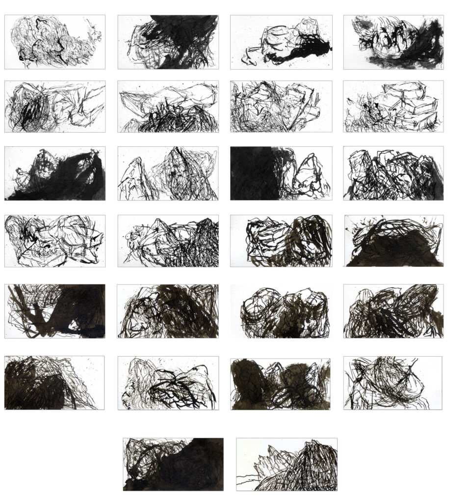
In diesem Sinne stellt Eismeer den Klimawandel nicht dar; es erprobt ihn strukturell. Die Unmöglichkeit, die Landschaft in einem einzigen Bild zu fixieren, die Notwendigkeit von Kooperation zur Aufrechterhaltung einer Gesamtheit, die Fragilität des Gefüges angesichts jeder Abwesenheit: All dies verweist auf eine zeitgenössische Bedingung des polaren Territoriums, ohne auf Rhetorik oder Spektakel zurückzugreifen.
![]()
Das Eismeer ist hier kein erhabenes Szenario, sondern ein System im Schwebezustand. Eine Landschaft, verteilt zwischen Koordinaten, Körpern und Zeichnungen, deren endgültige Form stets provisorisch bleibt.
![]()
![]()
![]()
Eismeer (Mar de hielo), 2012
Libro-objeto
9 × 26 cm, 26 partes
![]()
Eismeer (Mar de hielo) se presenta como un libro que ha abandonado la encuadernación para convertirse en una constelación de fragmentos portátiles. La obra está compuesta por 26 identificadores —credenciales individuales, pensadas para ser sujetadas al cuerpo—, cada uno de los cuales contiene un pequeño dibujo a tinta. Estos dibujos no son imágenes libres ni paisajes imaginados: cada uno corresponde a una coordenada específica localizada mediante Google Maps en el territorio antártico.
![]()
El gesto central de la obra no es la representación del hielo, sino su disgregación. El mar de hielo no aparece como una totalidad visual, sino como una suma de partes separadas, autónomas, desplazables. La referencia a Caspar David Friedrich no opera aquí como cita iconográfica, sino como resonancia estructural: así como en Das Eismeer el paisaje se fragmenta en placas violentamente superpuestas, en esta obra el territorio antártico se descompone en unidades mínimas, ya no pictóricas sino informacionales y corporales.
![]()
Cada identificador funciona como un fragmento de paisaje asignable a un cuerpo. La obra se activa plenamente sólo cuando veintiséis personas portan simultáneamente estos elementos, recomponiendo el mar de hielo a través de una distribución humana. El territorio, en lugar de ser contemplado a distancia, es sostenido, transportado y temporalmente encarnado. La cartografía deja de ser una abstracción global para convertirse en una coreografía colectiva.
![]()
El uso de Google Maps introduce una capa tecnológica decisiva: el acceso remoto, satelital y continuo a un territorio inaccesible para la mayoría. Sin embargo, lejos de reproducir la lógica de la imagen digital, Mercado traduce esas coordenadas en dibujo manual, reinstalando una temporalidad lenta y material. La tinta no busca describir el hielo con precisión mimética, sino registrar variaciones, densidades, tensiones gráficas: el dibujo aparece como un sismógrafo, no como una ilustración.
![]()
La escala del objeto —íntima, casi frágil— contrasta con la magnitud geopolítica y climática del territorio al que remite. Eismeer opera por desplazamiento: el hielo no se derrite en la imagen, sino que se fragmenta en el sistema que lo representa. El mar de hielo se vuelve divisible, asignable, portátil; su continuidad depende de una coordinación precaria entre cuerpos, datos y gestos gráficos.
![]()
Desde la perspectiva del dibujo contemporáneo, la obra propone una expansión del campo: el dibujo ya no es sólo superficie y trazo, sino también dispositivo de activación, interfaz entre datos satelitales y presencia humana. Desde la tradición del libro de artista, Eismeer desplaza la lectura hacia una experiencia espacial y social, donde cada “página” existe sólo en relación con las demás.
![]()
En este sentido, Eismeer no representa el cambio climático; lo ensaya estructuralmente. La imposibilidad de fijar el paisaje en una sola imagen, la necesidad de cooperación para sostener una totalidad, la fragilidad del conjunto ante cualquier ausencia: todo en la obra señala una condición contemporánea del territorio polar, sin recurrir a retórica ni espectacularidad.
![]()
El mar de hielo, aquí, no es un escenario sublime, sino un sistema en suspensión. Un paisaje distribuido entre coordenadas, cuerpos y dibujos, cuya forma final permanece siempre provisional.
![]()